
Yorkshire Dales Walks
Cobscar Mill & Preston Scar
Date: 4th Jan 2015
Distance: 7.8 miles
Ascent: 850 feet
Time: 3 hours 45 mins
With: On my own
Start Grid Ref: SE070911
Walk Summary:
An interesting walk contrasting the limestone scenery of Preston Scar and the grouse moors above including a visit to the mining remains at Cobscar Mill.
Route Summary: Preston-under-Scar - The Stanney - Preston Scar - Cobscar Mill - Tewfit How - Cranehow Bottom - Preston Moor - Black Beck Bridge - Wimp Hill - Herontree Allotment - Gillfield Wood - Preston-under-Scar
Photos: Click on the photos below to enlarge.


Video:
Walk Detail: After a cracking walk along Ellerkin Scar in Wensleydale just before Christmas I wanted to go back and visit some of the other limestone scars that are such a feature of that particular dale. Driving back from that previous walk I'd also seen the large chimney up on Redmire Moor, reminding me of another place I've been meaning to visit for a while. As a result I came up with this route combining the limestone scenery of Preston Scar and Redmire Scar with a visit to the remains of Cobscar Mill on the grouse moorlands above.
It was a cold, clear morning (-2 degrees on my car's thermometer) when I arrived in the village of Preston-under-Scar, an aptly descriptive name for the attractive village nestling below Preston Scar. Parking carefully in the village I initially located a pleasant path running immediately above and behind the village below a small wooded scar that I'm told is called The Stanney. Even at this stage there were some glorious views across the top of the rooftops down the dale towards Addlebrough and across the valley to the slopes of Pen Hill.
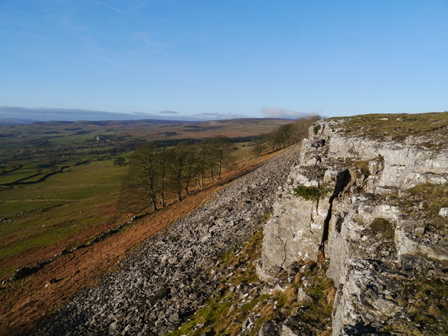
Taking a path climbing up The Stanney I then crossed a pasture to slant up a path alongside Pasture Wood on to the scar itself. The following promenade along the top of Preston Scar, briefly interrupted by the road at Scarth Nick, was quite delightful. The views of Wensleydale, although occasionally obscured by trees, were simply superb, ridiculously so for the lack of effort needed to enjoy them.
Reaching the point where, due to parish boundaries, Preston Scar becomes Redmire Scar I resisted the temptation to explore the remains of Redmire Quarry as it is not in access land and there are no rights of way. Instead I took a path between Redmire Quarry and Wensley Quarry to reach the moorland behind them. Crossing an area of new saplings I arrived at the remains of the old flue.
Ignoring the line of the right of way on the map I instead followed the flue up to the remains of Cobscar Mill. According to the Northern Mine Research Society website the mill was originally built as a smelting mill around 1762 but once the initital mines had been exhausted closed about 1830. It re-opened again in 1848 to finally close about 1890. Coal and calamine were also mined in the area. The ruins of the mill itself aren't that extensive, by far the finest object is the magnificent chimney at the head of the flue which is still in quite good condition.
After taking numerous photos of the chimney I followed a track down to a junction and made a short detour to view a mine reservoir which apparently is called Gull Island. Returning to the track I headed north on to Preston Moor. Continuing north I arrived at a well built cairn at a junction of tracks. Attached to the cairn was a recent memorial plaque to Henry Cubitt, 4th Baron Ashcombe, who died in 2013. After doing a bit of research on the internet I found out that Baron Ashcombe was Camilla Parker-Bowles' uncle and whose main connection to Yorkshire seems to have been managing a grouse moor on behalf of a Saudi prince. Presumably it was Preston Moor.
From the cairn I decided on a detour, this time west, so that I could visit the pile of stones on the moorland bump of Tewfit How. It was worth the effort for another super view across Wensleydale, this time dominated by the moorland heights to the north of the valley. Returning to the cairn I then dropped down into Cranehow Bottoms where I sat beside a shooting hut to enjoy something to eat for lunch.
After lunch I next took the track leading east across Preston Moor to arrive at the road alongside the Bellerby Ranges. After a very brief section on the road I then took an almost dead straight path from Wimp Hill south alongside a wall, on the very edge of the firing range, to reach the Scarth Nick road. Crossing over I then continued to descend on a track on the outside of Gillfield Wood. Finally I took a path through the wood itself for a delightful interlude featuring another close up of the flue and a series of small bridges over the numerous streams in the woods.
This was another hugely enjoyable walk in Wensleydale though on this occasion, not a footstep was actually in the Yorkshire Dales National Park. Presumably the presence of the quarries and army range meant that this area was left out. Certainly the scenery was in no way inferior, indeed the views from Preston Scar were magnificent.


Follow me on ...


